


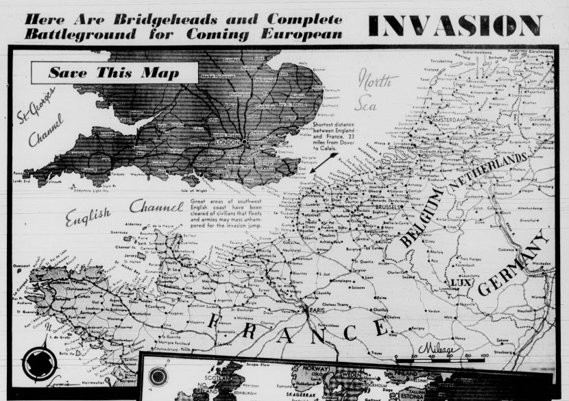
Here Are Bridgeheads and Complete Battleground far Coming European
by Stott Artiiti Aiax
Where and when General Eisenhowers Allied forces will invade western Europe is the worlds best secret. These maps are published that readers may save them for "D Day" and check the attack movements to be told in this newspaper. While the top map details the invasion coast from northwest Germany down to the south shore of the Brittany peninsula of France, the lower map covers the entire European battleground. Numbers on the lower map indicate Allied territories as follows: 1 - The western invasion zone. 2 - The central Mediterranean zone, where Eisenhowers move in the west may signal new amphibious movements against northern Italy (Genoa, La Spezia) or southern France (Marseille, Toulon). 3 - The east Mediterranean zone, where Allied armies from the Near East and Egypt, possibly operating from Turkey, may match Eisenhowers coup with an invasion of the southern Balkans on a Baghdad-to-Berlin march. 4 - The Russian theater, where even more accelerated Soviet pushes may coincide with Eisenhowers west assault. Red arrows show direction of the current Soviet drives into Poland, the Balkan nations and the Crimea, whose progress may key into the western invasion. On the west coast the Germans have the vaunted West Wall or Todt line of fortifications which reputedly cover every inch of coast with armament ranging from machineguns to mighty cannon, and with defense in depth protecting the coast for many miles behind. A splendid system of roads and rear fighter airbases is at the disposal of whatever mobile reserve strength (sometimes set at twenty-three divisions) Hitler can muster to send against whichever | intend salient Eisenhower may be able to develop. Perhaps the Allies will strike hard at several points before main push.
Detroit evening times